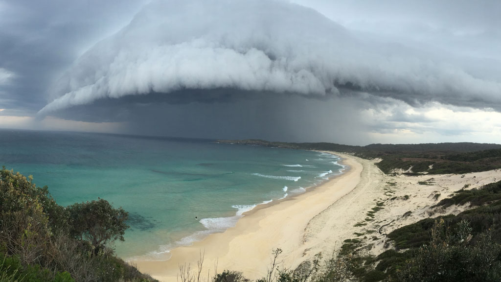
In an unusual and alarming turn of weather events, meteorologists have confirmed that a bomb cyclone is forming off the coast of New South Wales (NSW) and is likely to affect Sydney and surrounding coastal areas over the coming days. The Australian Bureau of Meteorology (BOM) has issued multiple warnings, alerting residents to intense rainfall, powerful winds, dangerous surf, and possible flash flooding.
As this powerful system gains momentum, understanding what a bomb cyclone is—and how it could impact daily life—is crucial for residents and travelers across NSW.
This blog unpacks the science behind bomb cyclones, what to expect from this particular event, the areas most at risk, and how to prepare.
What Is a Bomb Cyclone?
A bomb cyclone, also called explosive cyclogenesis, refers to a mid-latitude storm that intensifies rapidly, with its central pressure dropping by 24 millibars or more within 24 hours. These storms are typically accompanied by:
- Torrential rain
- Damaging winds (often over 100 km/h)
- Coastal erosion
- Large ocean swells
- Thunderstorms and hail
In essence, it’s a fast-developing low-pressure system that gains strength quickly—similar to a cyclone but occurring in cooler, non-tropical regions.
Although bomb cyclones are more common in the North Atlantic or North Pacific, they can occur in the Southern Hemisphere too, especially during Australia’s winter months.
Why Is It Happening Now?
According to BOM, this bomb cyclone is forming due to the interaction between a deepening cold front from the south and warm ocean air from the Tasman Sea. The rapid change in atmospheric pressure is creating the perfect conditions for explosive cyclogenesis.
This system is expected to develop just offshore but could bring damaging weather to land as it moves closer to the NSW coastline.
Key contributors:
- Strong jet streams
- Cold air masses descending from Antarctica
- Moisture-laden winds from the east
- Low sea-level pressure near the coast
Expected Timeline and Duration
📅 Key Dates:
- Development Phase: July 3–4
- Peak Impact in Sydney & NSW Coast: July 4–6
- Dissipation/Movement Away: July 7 onward (weather dependent)
The intensification is likely to begin on July 4, with the most severe conditions expected between late Thursday and Saturday morning, depending on how close the system tracks to the coast.
Areas Most at Risk
While Sydney is expected to feel the effects of this storm, several coastal and inland areas are at higher risk, including:
- Greater Sydney Metropolitan Area
- Illawarra Region (Wollongong, Kiama)
- South Coast (Batemans Bay, Moruya)
- Hunter Region (Newcastle, Port Stephens)
- Central Coast (Gosford, Terrigal)
- Blue Mountains – due to elevation and slope instability
- Far South Coast – for storm surges and wind
The marine environment is particularly vulnerable, with dangerous conditions expected for boaters, surfers, and fishers along the coastline.
Weather Impacts to Expect
🌧️ 1. Heavy Rainfall & Flash Flooding
- Rainfall totals could reach 100–200 mm in 24–36 hours.
- Urban flooding is likely in low-lying parts of Sydney and coastal towns.
- River catchments may overflow in areas such as the Hawkesbury-Nepean.
💨 2. Damaging Winds
- Gusts could exceed 90–110 km/h in exposed coastal areas.
- Fallen trees, power outages, and infrastructure damage are possible.
- Air travel delays at Sydney Airport should be expected.
🌊 3. High Surf and Coastal Erosion
- Wave heights may exceed 6–8 meters offshore.
- Coastal erosion is a serious risk from Newcastle to Eden.
- BOM may issue marine gale warnings for small boats and yachts.
⚡ 4. Thunderstorms and Hail
- Isolated thunderstorms are possible as warm and cold air interact.
- Hailstorms could accompany these cells, particularly on July 5.
Safety Measures to Follow
🏠 If You Live in Affected Areas:
- Clear gutters, drains, and debris from your property.
- Secure outdoor furniture, trampolines, and loose objects.
- Charge electronic devices in case of power outages.
- Avoid driving in flooded areas and keep emergency numbers handy.
🚫 If Traveling:
- Monitor BOM alerts for road closures and landslides.
- Consider postponing travel along the Princes Highway and Pacific Motorway.
- Check for flight delays or cancellations at Sydney, Newcastle, and Canberra airports.
⛴️ If You’re at Sea or Coast:
- Cancel all small vessel activities and ferry rides.
- Avoid cliffs and coastal walking tracks.
- Stay away from rock platforms and unstable beaches.
How Government and Emergency Services Are Responding
The NSW State Emergency Service (SES) has already mobilized teams in anticipation of storm-related emergencies. Sandbags are being distributed in flood-prone areas, and evacuation plans are in place for at-risk suburbs.
The Bureau of Meteorology is updating its warning system in real-time, including Severe Weather Warnings and Thunderstorm Alerts.
📱 Download These Essential Apps:
- BOM Weather App – for official forecasts and alerts
- NSW SES App – to request help and find safety tips
- Live Traffic NSW – for up-to-date road conditions
Could This Bomb Cyclone Become a Named Storm?
Australia typically doesn’t name non-tropical cyclones, but if the system brings severe and widespread impacts, it might receive internal tracking names for easier public communication, especially on emergency channels and media platforms.
Long-Term Climate Implications
Meteorologists suggest that warming ocean waters and climate variability may increase the intensity of such events in the future. While bomb cyclones are still rare in Australian waters, changing weather patterns could make extreme low-pressure systems more common along the southern coastlines.
What to Watch After the Cyclone
Once the storm system moves away from the east coast, lingering effects may still include:
- Flooded farmlands and roads
- Fallen trees and power lines
- Disruptions to school and office reopenings
- Prolonged restoration of utilities in hard-hit regions
Emergency services urge residents to remain vigilant even after the storm passes, as residual flooding and landslides may occur up to 48 hours later.
Final Thoughts: Be Alert, Not Alarmed
While bomb cyclones are dramatic in name and nature, timely precautions and coordinated emergency response can significantly reduce harm. As the storm approaches Sydney and the NSW coast, stay informed, stay indoors when advised, and follow safety protocols.
Nature’s fury may be intense, but preparedness is always the best defense.
FAQs: Bomb Cyclone in Australia
Q1. What is the difference between a cyclone and a bomb cyclone?
A1. A cyclone typically forms in the tropics and involves warm-core systems. A bomb cyclone forms outside tropical zones and involves rapid pressure drops, but it’s not a tropical cyclone.
Q2. Has a bomb cyclone ever hit Australia before?
A2. While rare, Australia has experienced explosive low-pressure systems similar to bomb cyclones, especially in southern ocean regions.
Q3. How long will the Sydney bomb cyclone last?
A3. Impacts are expected from July 4 to 6, with residual weather concerns up to July 7.
Q4. Can I still go to work or school during the storm?
A4. Local authorities will advise based on conditions. Stay tuned to SES updates and local councils.
Q5. Will this affect electricity and phone lines?
A5. High winds may cause power outages and temporary service disruption in some areas.